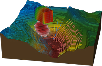
SoilVision applications provide capabilities for engineering related to soil properties, soil behaviour, and groundwater flow.
Bentley acquires key software firms
01 June 2018
Bentley Systems, a global provider of comprehensive software solutions for advancing infrastructure, says it has acquired Plaxis, a geotechnical software company based in Delft, Netherlands.
The company has also reached an agreement to acquire soil engineering software provider SoilVision, based in Saskatchewan, Canada.
Founded in 1997, SoilVision has championed 3D conceptual design and analysis of slope stability, groundwater flow, stress/deformation, contaminant transport, thermal flows in saturated/unsaturated soils, and coupled processes for geotechnical engineers and hydrogeologists.
The acquisitions, with Bentley’s market-leading borehole reporting and data management software gINT, serve to make Bentley a complete source for geotechnical professionals “going digital.”
Finally, BIM advancements can be extended to the essential subsurface engineering of every infrastructure project. Projects necessarily begin with geotechnical surveys and sampling, captured with gINT for versatile documentation and reporting. Next, professionals perform engineering related to soil properties, soil behaviour, and groundwater flow using SoilVision’s SVOffice applications, supplemented by Plaxis’ offerings.
 |
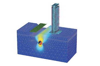
Plaxis 3D performs three-dimensional analysis of deformation, soil-structure interaction, and stability in geotechnical engineering and rock mechanics. |
Then soil-structure interaction is analysed through Plaxis’ design, simulation, and engineering software (for example, Plaxis 2D and Plaxis 3D).
The new opportunity, by way of digital workflows enabled through Bentley’s comprehensive modelling environment, is for geotechnical applications to be integrated with Bentley’s structural applications (such as STAAD, RAM, and SACS) for unprecedented geo-structural engineering performance, says the software solutions provider.
As changes may occur in owner requirements, structural strategies, or site conditions (continuously surveyed through unmanned aerial vehicles and Bentley’s ContextCapture for reality modelling), geotechnical analysis could be continuously applied for improved outcomes, as managed through ProjectWise collaboration services.
“For today’s infrastructure demands, geotechnical considerations are coming to the fore. Urbanisation, for instance, drives growth both vertically and underground, with an emphasis on the capacity of foundations and tunnels. And new infrastructure projects of every type depend upon constructed dams, embankments, dikes, levees, and reservoirs to improve their resilience. Moreover, new asset types such as offshore wind turbine structures require new geotechnical analysis capabilities, in this case to be accomplished with Plaxis’ forthcoming MoDeTo software,” says a spokesman for Bentley.
Because infrastructure assets are crucially linked to subsurface environs, they are vulnerable to geo-environmental risks including seismic activity, subsidence, and weather impacts. Leveraging new digital workflows which incorporate real-time monitoring and analytics during infrastructure operations, geotechnical professionals can play the increasingly valuable role in achieving geo-environmental resilience, he adds.
Bentley points out that while most infrastructure engineering disciplines converged around intuitive 3D models, geotechnical applications seemed to have followed a less graphically intensive development path, and so have remained isolated from cross-discipline workflows.
“This ‘disconnected’ mindset prevailed even while Plaxis, SoilVision, and gINT mainstreamed 3D innovations. Our BIM platform’s comprehensive modelling environment will finally embrace the geotechnical profession in digital workflows for every infrastructure project and asset,” he notes.
Tony O’Brien, global practice leader for geotechnics for Mott MacDonald, says Plaxis was one of its core analysis tools being used across global geotechnics practice.
“When used by experienced specialists, Plaxis can analyse many of our most complex ground-structure interaction problems. In Bentley’s hands, we have high expectations that we can accomplish more through digital workflows made possible through integration of Plaxis technology with Bentley’s comprehensive modelling environment – workflows that are compatible with Mott MacDonald’s commitment to connected thinking and solving complex infrastructure challenges,” he adds.


